How to use this map
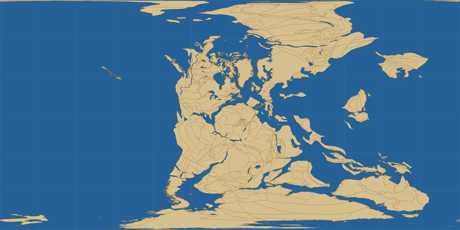
Drag the slider or tap a button to jump between seven moments in Earth’s history, from 750 million years ago to today. Tan shapes are land and blue is ocean. Watch how the pieces drift, crash together into Pangaea, then split apart into the continents you know. Start at Pangaea, then step forward one era at a time. It is the easiest way to see the Atlantic Ocean being born.
Why do continents move?
Earth’s outer shell is broken into about 15 large plates, like a cracked eggshell. Under them, the mantle is hot rock that flows very slowly. Plates move a few centimetres a year, pulled down where they sink into the mantle at ocean trenches and pushed apart where new crust forms at mid-ocean ridges. Over millions of years, those small movements add up to thousands of kilometres.
A German scientist, Alfred Wegener, suggested “continental drift” in 1912 after noticing that South America and Africa fit together like puzzle pieces and share the same fossils. Many people did not believe him until the 1960s, when maps of the sea floor proved that oceans spread from ridges. Today GPS can measure plate movement directly.
The eras at a glance
- 750 million years ago – Rodinia breaks apart: Most land was joined in a supercontinent called Rodinia, which was starting to split. Life was still tiny and mostly single-celled, living in the sea. Soon after, Earth went through “Snowball Earth” ice ages, when ice may have reached close to the equator.
- 540 million years ago – Cambrian explosion: The land is scattered, and a big southern landmass called Gondwana is forming. In the seas, animals with shells and hard parts suddenly appear in the fossil record, including trilobites. Land itself was still bare rock, with no plants or animals on it.
- 250 million years ago – Pangaea: Almost all land has crashed together into one supercontinent, Pangaea, surrounded by a single ocean called Panthalassa. This is about when the biggest mass extinction in Earth’s history happened, at the end of the Permian, wiping out most sea species. Early dinosaurs appeared a little later, in the Triassic.
- 150 million years ago – Jurassic dinosaurs: Pangaea is splitting into a northern part, Laurasia, and a southern part, Gondwana. The young Atlantic Ocean is opening between North America and Africa. Giant long-necked dinosaurs like Brachiosaurus and early birds such as Archaeopteryx lived at this time.
- 66 million years ago – End of the dinosaurs: The continents look much more familiar, but India is still an island heading north and Australia is still joined to Antarctica. A large asteroid hit near what is now Mexico’s Yucatán Peninsula, and together with huge volcanic eruptions in India this ended the age of the non-bird dinosaurs. Mammals and birds then spread out.
- 20,000 years ago – Last Ice Age: Continents are where they are today, but huge ice sheets cover much of North America and northern Europe. Sea level was about 120 metres lower, so land bridges joined Asia to North America and Britain to Europe. Early humans, mammoths and woolly rhinos lived through this cold time.
- Today – Earth today: Seven continents and five oceans. The plates are still moving, about as fast as your fingernails grow, a few centimetres a year. The Atlantic is getting wider, the Pacific is shrinking, and Africa is slowly splitting along the East African Rift.
How accurate are these maps?
Older maps are less certain. Rocks from hundreds of millions of years ago have often been melted, folded or worn away, so scientists rebuild old positions from magnetism locked in rocks, fossils and the shapes of mountain belts. Different research teams draw slightly different maps, especially before Pangaea. Our maps use the Merdith 2021 plate model through the free GPlates Web Service. They show reconstructed coastlines, not detailed sea levels, ice or mountains. The Ice Age map comes from the PALEOMAP project and shows ice sheets and the lower sea level.
Fun things to look for
- Find India 66 million years ago: it is an island racing north. When it hit Asia it pushed up the Himalayas.
- Look at 250 million years ago: you could have walked from today’s Antarctica to Canada.
- Compare 20,000 years ago with today to spot the land bridge between Russia and Alaska.
More to explore
See how our planet has changed in recent decades in Earth Then and Now and the Earth year by year timelapse. If you want to type in your home town and see where it was on an ancient globe, the independent site Ancient Earth globe by Ian Webster is a fun outside resource (opens in a new tab; not affiliated with us). Scientists and students can try the free GPlates software.
Frequently asked questions
What was Pangaea?
A supercontinent that held almost all of Earth’s land about 335 to 175 million years ago, before it broke up into today’s continents.
How fast do continents move?
Usually 2 to 10 centimetres a year, about as fast as fingernails grow.
Will the continents join again?
Many geologists think so, in roughly 200 to 250 million years, forming a new supercontinent sometimes called Pangaea Ultima or Amasia.
Is this the Ancient Earth globe by Ian Webster?
No. This is our own map made from open scientific data. We link to his site as an outside resource.
Data and credits: Palaeo-coastlines for 750, 540, 250, 150, 66 and 0 million years: GPlates Web Service (EarthByte Group, University of Sydney), plate model Merdith et al. (2021) “Extending full-plate tectonic models into deep time”, Earth-Science Reviews, CC BY 4.0; maps drawn by ViralScopeHub. Ice Age map: “Mollweide Paleogeographic Map of Earth, 0Ma (Last Glacial Maximum)” by Scotese, Vérard, Burgener, Elling and Kocsis, PALEOMAP project, CC BY 4.0, via Wikimedia Commons, resized. See all Live Earth & Space tools and our credits page.